*
*
More than anywhere else on earth from the sky, Lahaina looks like a beautiful soaring bird even as it dove into flaming heaps of coal and ash in the twilight of August 8. My sorely heavy heart will never forget you.
Truth is a love-letter from the soul.
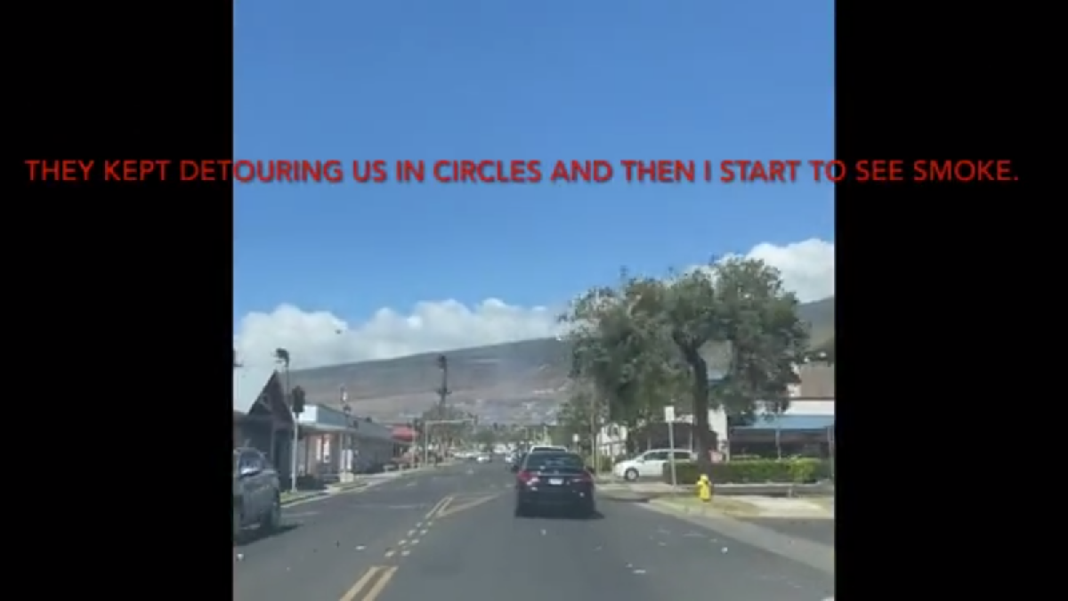
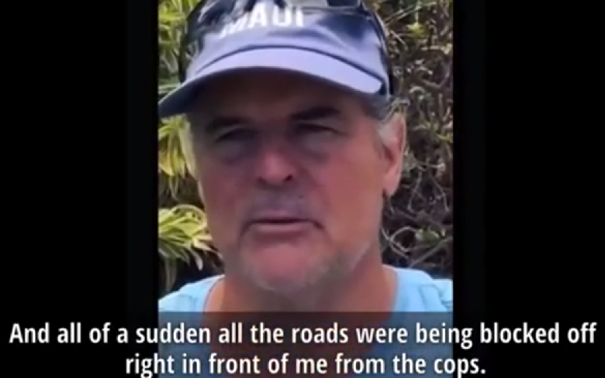
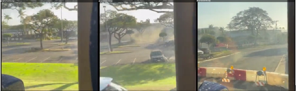
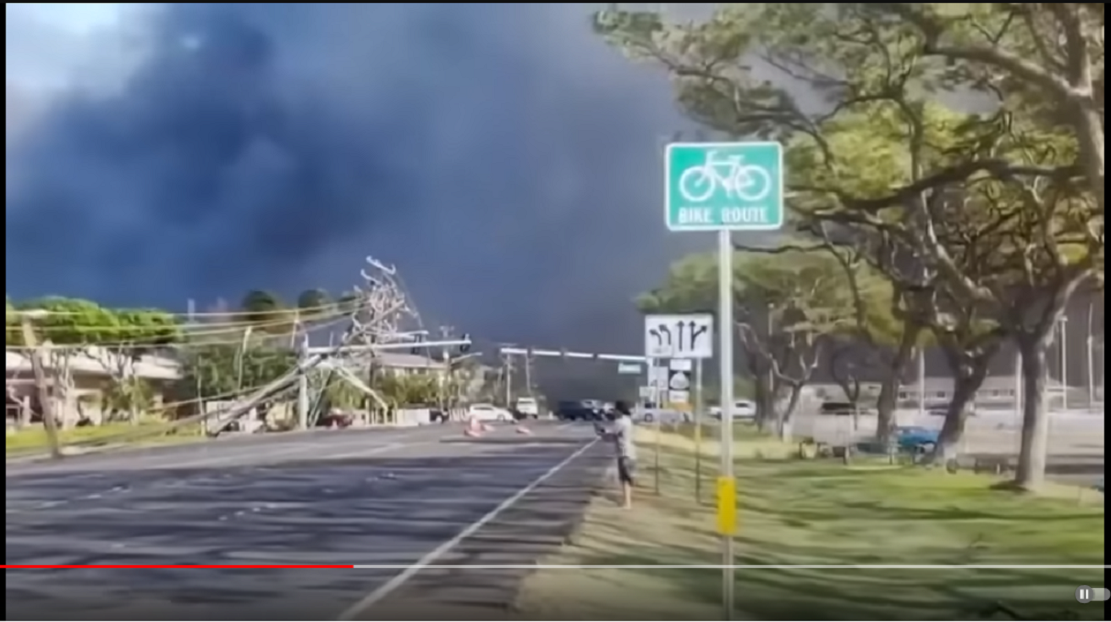
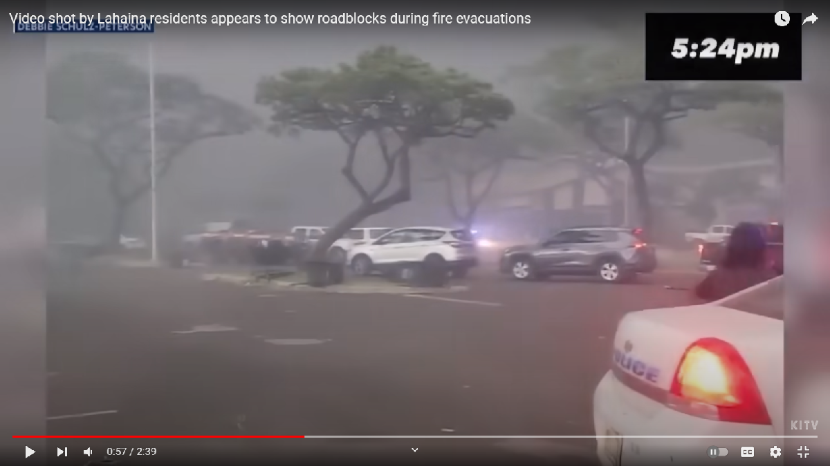
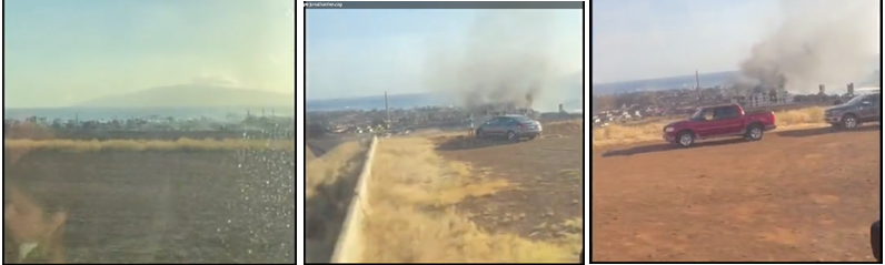
On August 17th I saw the video that made me understand. Jonathan Herzog was trying to drive through Lahaina town some time before 2:30pm and found himself officially diverted within the confines of the danger zone in the path of the coming fire. He wrote on his video “They keep detouring us in circles.” On a pass up Front Street timestamped 2:36, wind and debris was pulling down the power lines and Jonathan knew he was “in a bad place”…
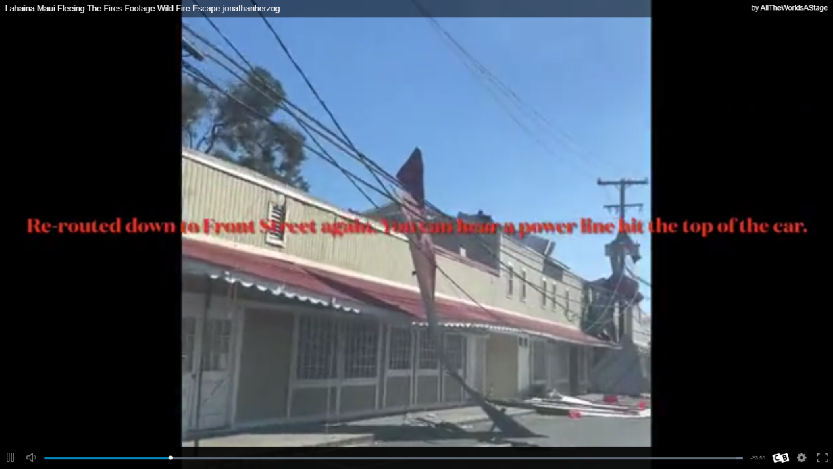
“…Fleeing the Fire…Jonathan Herzog”/posted by ‘All The World’s A Stage’ 8-17-23 https://153news.net/watch_video.php?v=MWX7KRUB526O
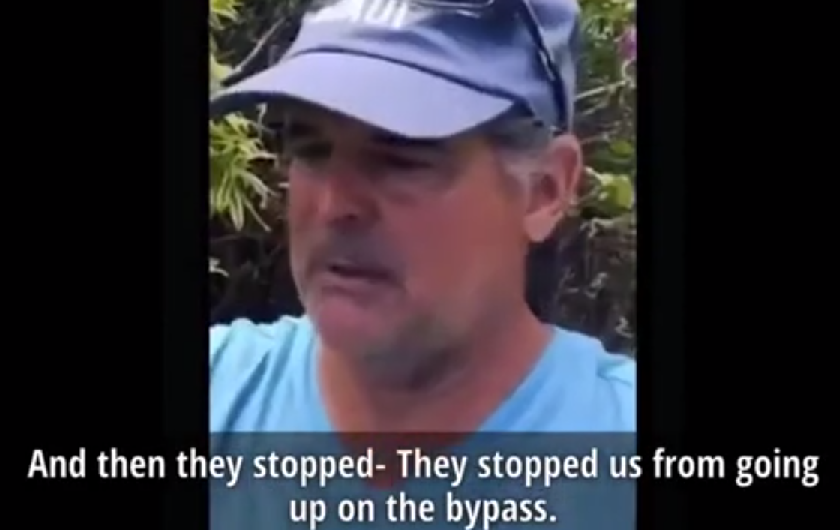
Jonathan ditched his car in a church parking lot, and not a moment too soon it appears, headed for a jetty in the harbor a block away until it too was a bad place where the smoke would overtake him– he moved north along the shore to the cluster of resorts and found a room to spend the night. And on the next day, the 9th, he got a bus ride back into town. (minute 33)
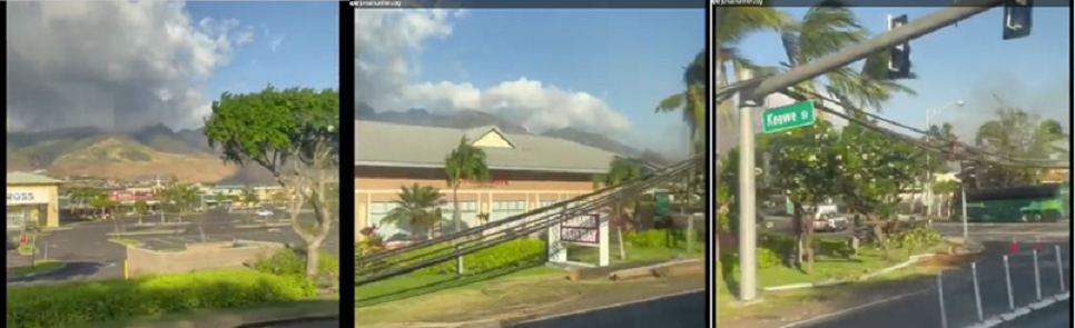
From the window of a tour bus, we see his motorcade passing the ashen ruins until they reach the unburned shopping center and turn left onto Keawe St, “the Gateway,” beginning and end of the Lahaina Bypass (Hwy 3000). Behind them now is the Safeway grocery store, the safe way off of Front St. and up the hill (mauka). Just the day before, about the same time of day, Jonathan was very close to it.
*
*
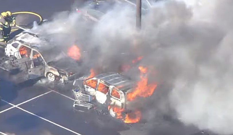
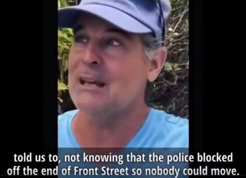
Please, especially, listen and watch Fish speak with Eric West for 30 minutes, found here. https://greatmountainpublishing.com/2023/08/24/police-blocked-roads-to-prevent-residents-from-fleeing-the-immolation-of-lahaina/ ; Fish was at the Safeway when smoke came pouring into the Gateway which was closed to traffic. People there couldn’t see beyond the smoke but if they had, they would have known there were no flames coming from the buildings along Keawe Street. The toxic smoke, I’m guessing, came from the fenced car lot of about 50-60 cars behind the undamaged Mormon church, a block up from the shopping center. Toasted cars turned up in unusual places.
Another “Man escapes Maui Police KILL ZONE…” https://153news.net/watch_video.php?v=HAU193YHHR23
______________________________________________________
Truth is a love-letter from the soul. Write it on your heart so you’ll remember
in time of need the Sender who Loves and made you whole.
______________________________________________________
going mauka
“We didn’t want people going mauka”–Herman Andaya, in answering the failure to sound the warning sirens.
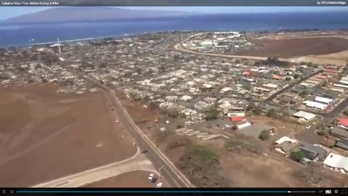
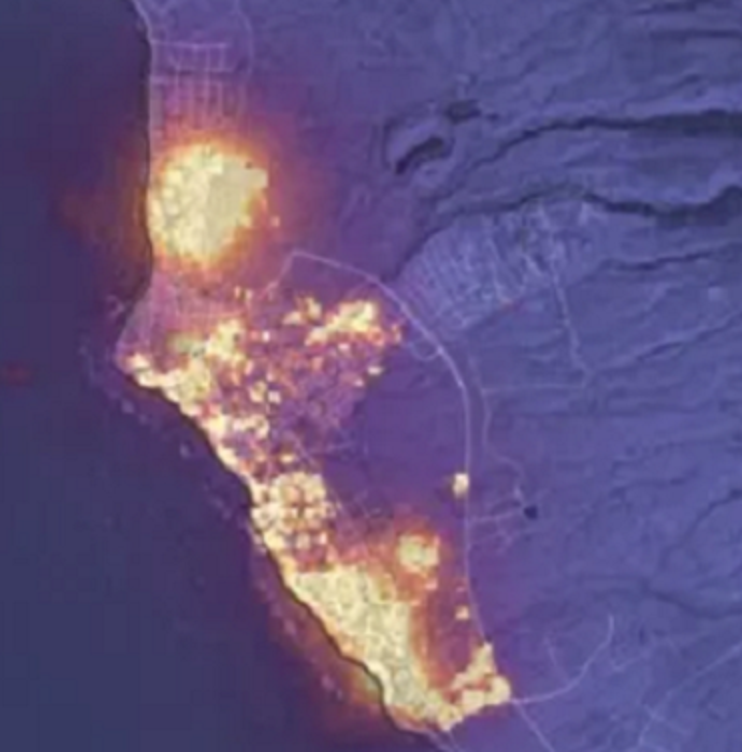
image source: ‘Lahaina Maui Before During & After’ https://153news.net/watch_video.php?v=H8GB7D757M2S’
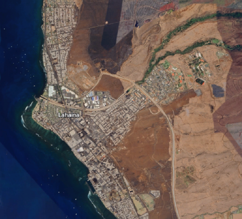
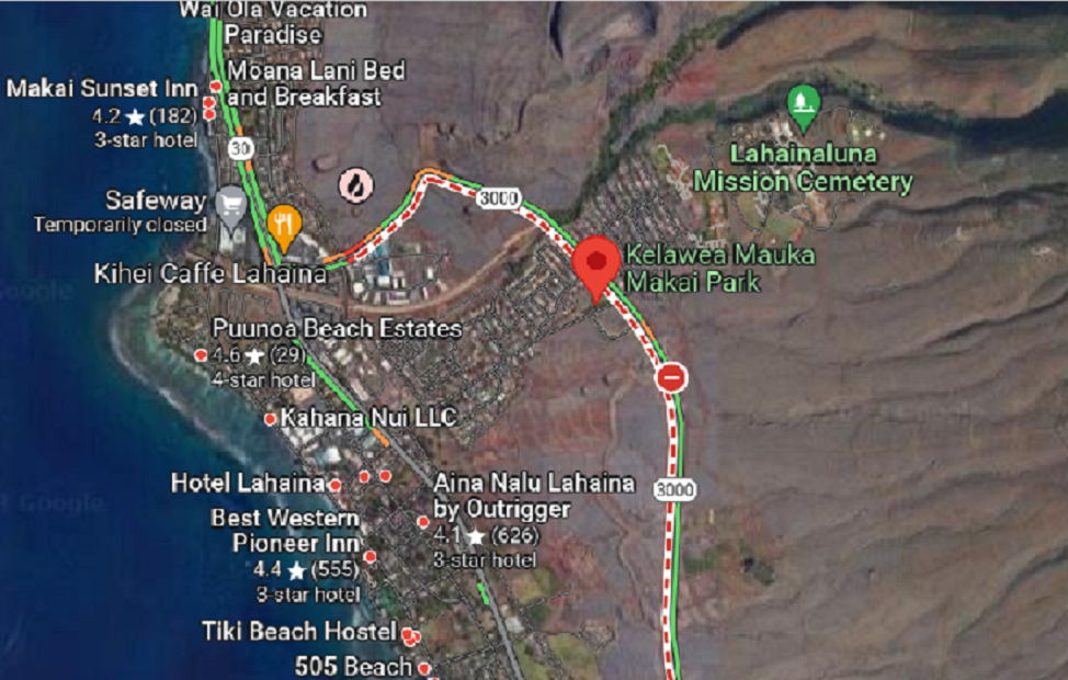
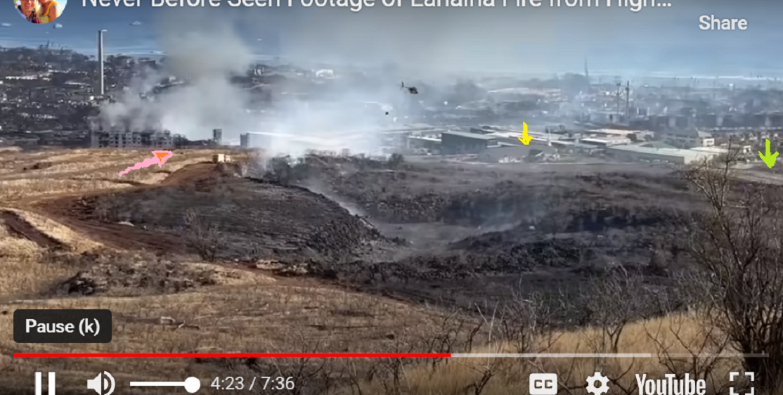
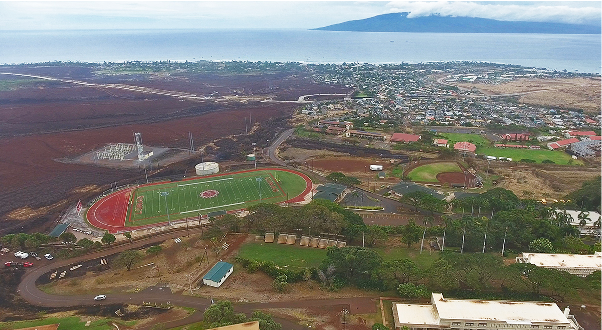
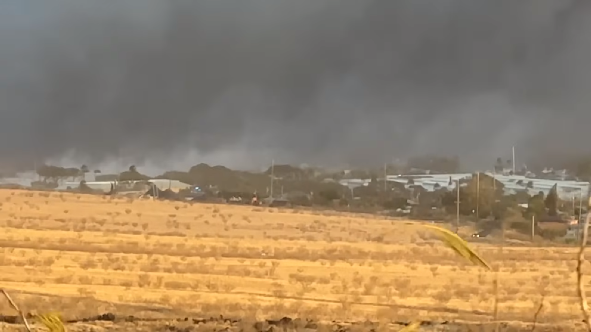
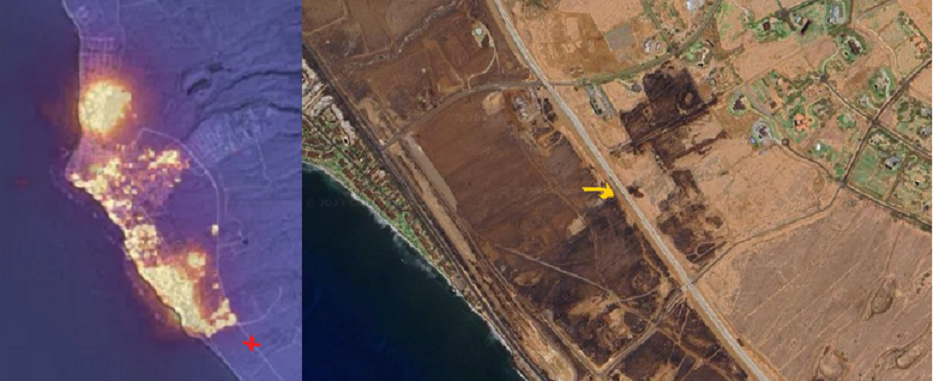
On the 9th around midday (noon?), this helicopter image was taken near the Bypass. The center foreground at the bottom of the picture shows a meeting place of east-west Lahainaluna Rd with the bypass entrance (elbow) on the left and the small Kelawea Mauka Makai park (with brown trees), flagged with a big red dot in the street map above. You can count the rows of unburned houses from the right, sited just below the Bypass in this picture. On both outer sides of row 4 appear to be flashpoints for the fires that seemed to burn downward and sideways, leaving only one blue-roofed house unburned in row 6 (looks turquoise here). No structures near the Bypass, or any above it were burned. NASA’s infrared “flaming bird” shot from the night before shows this high ground in utter blue-blackness except for one small hazy purple spot that is barely visible. I marked the ‘spot’ in daylight with purple in this after-fire image below from Google Earth. The spot , said to have flashed a fire in the grass on 8-8 around 6:30am in the morning, is where the official narrative begins and truth leaves off.
The yellow X on the Bypass is roughly the helicopter vantage point looking west-northwest.
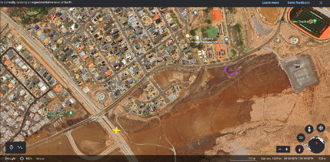
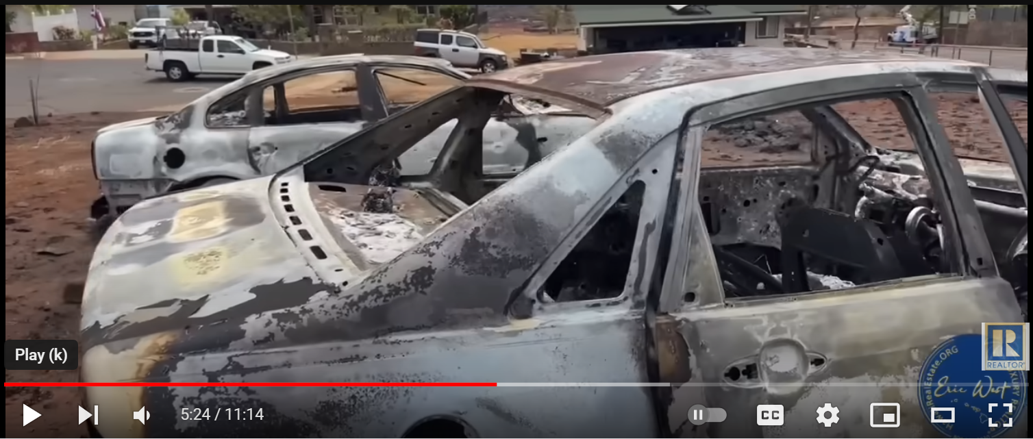
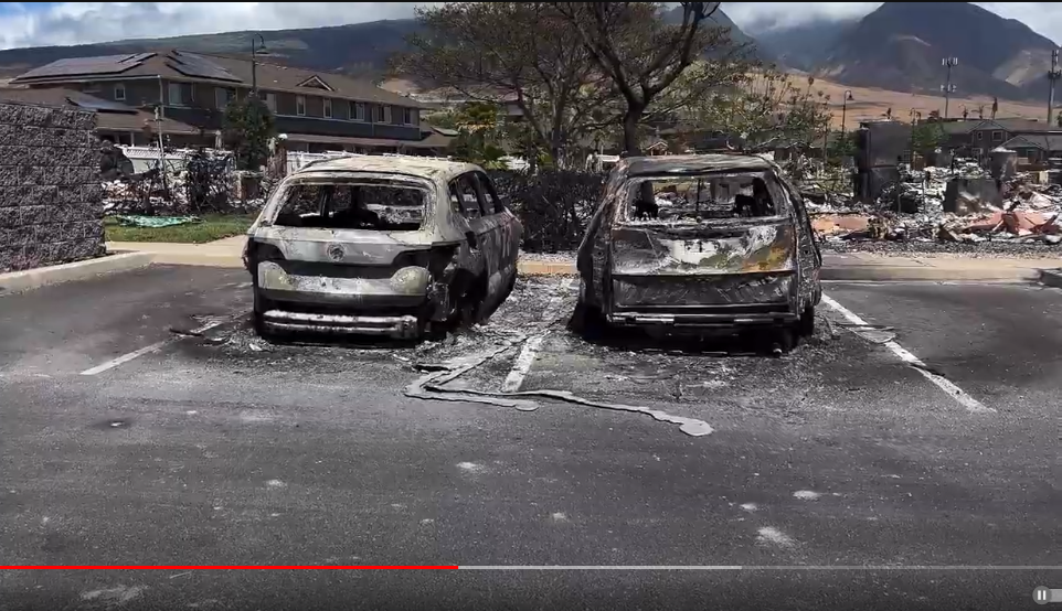
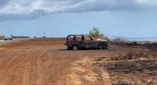
Also in this Google image is the closest cul-de-sac to the right of my yellow X appearing to have 2 totally toasted cars left where they melted. See them here in a video from Eric and friends— https://www.youtube.com/watch?v=Lg2WV-B26pA&t=328s; and a picture.
“…We’re right below Lahainaluna High School in an area that did not burn…so…this is like something out of a space movie… By the way, I just talked to a neighbor who was talking to an investigator in Lahaina town yesterday and he said the investigator told him temperatures reached in excess of three thousand degrees… [The authorities] don’t want anybody taking pictures, especially pictures like this…”
*
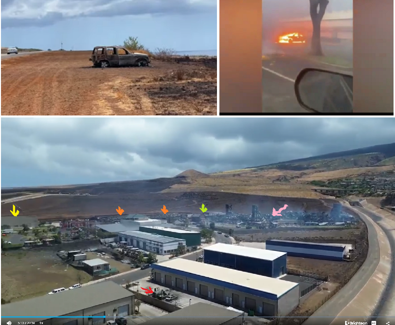
Arrows: yellow is the Mormon church roof, orange is one big car lot, green is unburned structures, pink is a large fully destroyed apartment building and red looks like three more isolated toasted cars. The Bypass is across the background above the field. Some unusual damage appears in the far left open space including charred green grass.
Source, drone(20minutes) https://www.brighteon.com/6abbd990-e859-44ff-a6e6-4843ae78beb0

Every car in the fenced lot behind the Mormon church was toasted but nothing else outside the lot looks damaged. On the 9th as Jonathan H. was riding up the Bypass, he held his camera on the church as the bus climbed Keawe Street. The plume of black smoke came from the big smoldering apartment block that burned for two days.
*
Here’s another angle and a link about this brand new 5-story apartment building at 258 Kupuohi Street that held its grand opening in December of 2022 https://affordablehousingonline.com/housing-search/Hawaii/Lahaina/Kaiaulu-O-Kupuohi/10112246 ; built by Hunt Companies https://www.huntcompanies.com/about-us/our-history specializing in privatized military housing, low-income and high-end ‘lifestyle’ developments. The picture above is another video from Eric West, taken I believe on the 9th. The firetruck near the pink arrow is extinguishing an intentional back-burn as I understand it, and fire crews expanded back-burning the next day farther north and east. As we know, on the 9th, many more homes were yet to burn. (yellow arrow is Mormon church, green on the far right is the Bypass) Black char, right there, is what a hot grass fire aftermath looks like. For comparison, tour Lahaina’s high ground after the August 2018 “Hurricane Lane” fire.
Image from 2022, #258 Kupuohi is under construction. https://duckduckgo.com/?q=258+Kupuohi+Street+Lahaina&t=brave&ia=web&iaxm=maps
2018 brush fire still pictures https://dmcleish.com/Maui2018/Lane-8-25-18/index.html ; “Hurricane Lane Fire Damage” video https://www.youtube.com/watch?v=w1xPZ2r8jDA&t=17s
*
Back at base, near the Safeway….
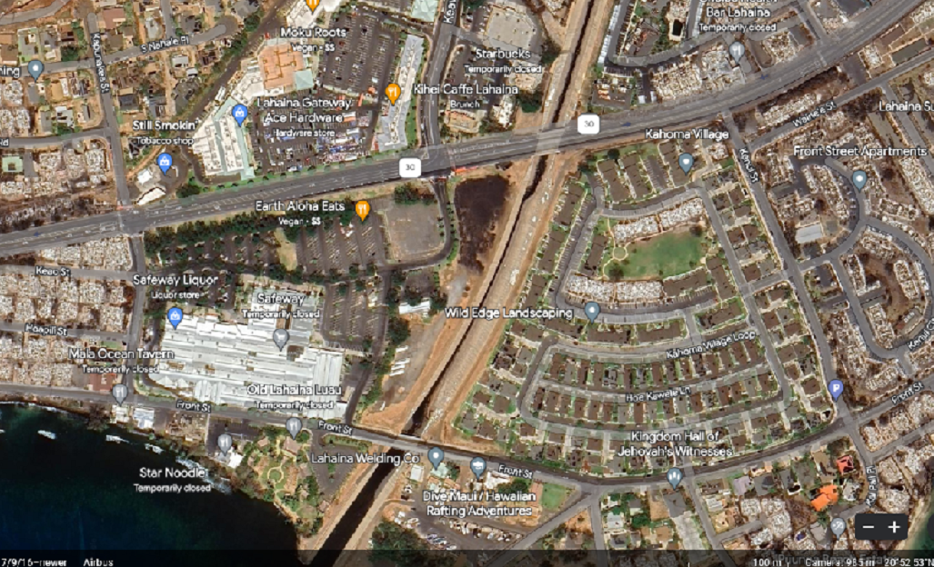
Kahoma Village ( by video walking tour) remained unscathed except for 4 buildings: shown here, toasted cars next to two of its destroyed low-income multi-unit ‘townhouses’. (–add a fifth building of one single family house destroyed in the upper right corner of the map below) Take the tour https://www.youtube.com/watch?v=9mppuqs7YF0
Smoked-out by burning cars: check this recent 19 second video taken Aug 25 at a shopping mall in Philadelphia where five or six cars closely parked erupted in flames https://www.youtube.com/watch?v=IsJjXlqcL_Y Here’s the scene:
*
Based on what can be learned from survivors and the lay of the land, I’m going to show you images and quote the witnesses who crossed the threshold of the Safeway, starting with Jonathan Herzog’s bus ride on the 9th.
Recorded from the window, looking west toward the water, here’s the Cannery Mall with Safeway in the background.
Seen from the right side bus window, Safeway’s north side-road, Kapunakea St, is blocked here. The Cannery’s south side-road at the intersection with Rt30 and Keawe is also blocked on this day and stood guard by police. You can catch a glimpse of the blockade as Jonathan pans over the intersection as they turn left up Keawe/Bypass.
Across the street is the Gateway shopping center. The parking lot later became the staging area for basic community services like food and supplies.
The Day Before (below): Reports showing video taken on the afternoon of Aug 8 at the Gateway were recently aired by KITV’s (abc4) Jeremy Lee
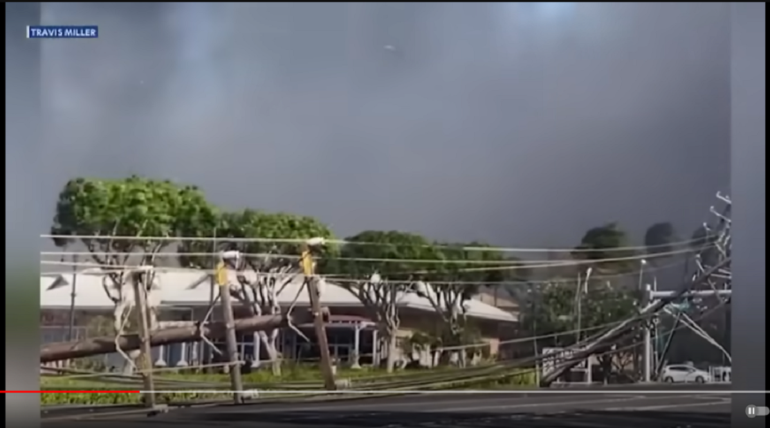
Travis Miller’s video at 3pm Aug 8 as he exited the Safeway.
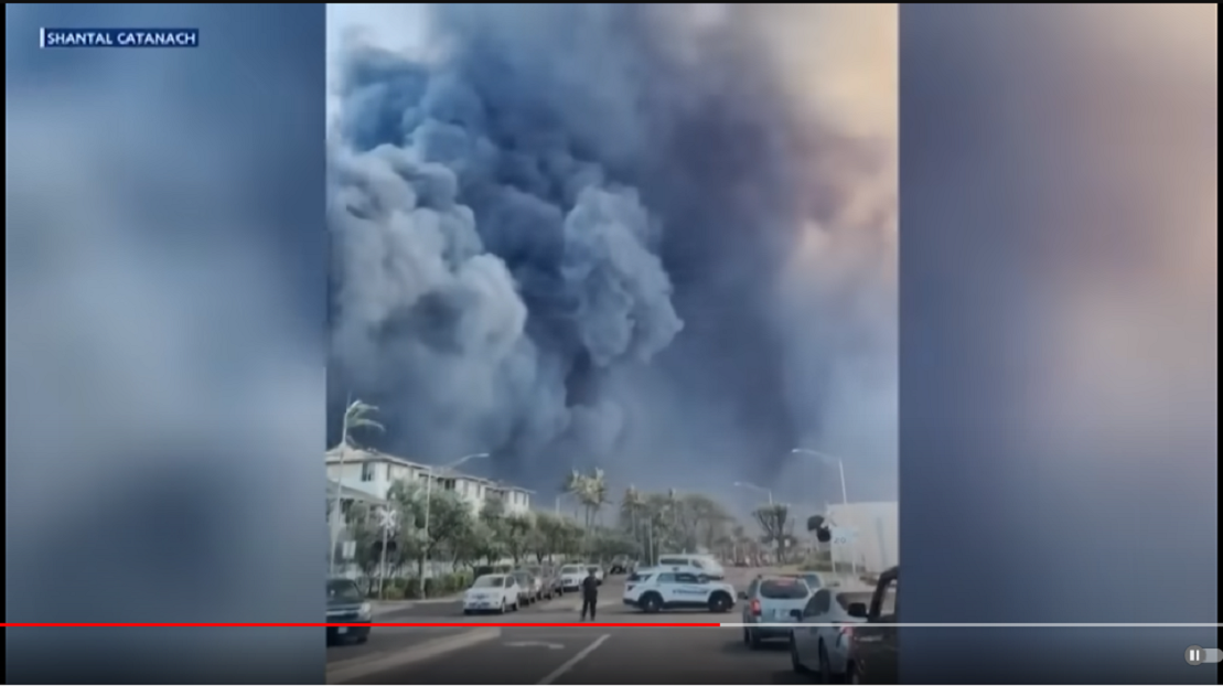
Below is Shantal’s video at 4:30 pm. Billowing smoke “near the Bypass” is pouring down into the intersection of Keawe and Rt30 heading toward the Gateway and Safeway. About an hour later, as Bethany told it to Eric West, she left her Kupuohi apartment (the big block behind the Mormon church) and was required to turn left down into the heavier smoke and drive straight through the intersection to the Safeway. When Bethany left the 5-story apartment house around 5:30pm it was not on fire but “smoke was everywhere.” Shantal’s video shows the Keawe/Bypass access was actually free of smoke.
Watch this 2:30 minute news report from KITV’s Jeremy Lee for the scenes shown above. He opens his statements standing in front of the unburned Kelawea Mauka Makai Park on Lahainaluna Road, captured in the helicopter footage at the highground Bypass next to the assumed flashpoint of the town fire. Jeremy also reports that Lahainaluna Rd was closed and blocked by police both north and south where it met Rt30, forcing people to cross and drive down to Front Street. https://www.youtube.com/watch?v=Qg2sfqTiGnc
[article] Highway exiting Lahaina blocked for 2 hours as motorists self-evacuated
A DAY AGO | By Jeremy Lee “LAHAINA– A Lahaina resident captured cell phone video over the course of two hours, revealing the highway shut down to traffic during the peak hours of the self-evacuation. Newly released cell phone video, shot by Travis Miller, captures the moment that downed power lines entangled cars on Honoapi’ilani Highway[Rt30] near Kapunakea [Safeway], one block north of Lahaina Gateway. It was just before 2:53 in the afternoon when the flow of traffic soon after halted.” https://muckrack.com/jeremylee
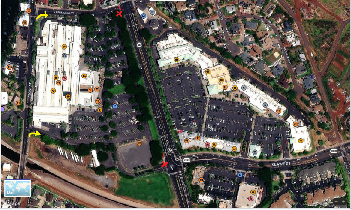
Yellow arrows connect Front Street to the Safeway parking lot. Red Xs show barriers present on the 9th.
The Aug27 news from KITV: “[studio] …”Jeremy spoke with residents who fled those fires.” [cut to Jeremy] “I’m standing here at this critical intersection of Keawe Street leading down to the Honoapilani Highway [Rt30] which runs south to north as the primary exit northbound from Lahaina town. Keawe Street also leads to the Bypass. The Bypass, we know, was closed at 3:30pm on August the 8th as firefighters battled the brush fire. I had a chance to ask the Chief of Police [who doubly performs as Coroner] about the road closure which occurred here when downed power lines shut down Honoapilani [Rt30] northbound. Witnesses tell me traffic was directed down Keawe Street and into the mall behind me—The Cannery, the only exit [remaining]on the other side of the Cannery is Front Street. [Witness Travis Miller:] ‘All the people that I saw were directed…into the Cannery parking lot…’ [Cut to Chief John Pelletier at a press conference]…”let me answer it like this. There is going to be a very detailed long after-action. There might be the longest after-action that has ever been. Every data point is going to be scrubbed and looked at [-said while shaking his head side-to-side in the ‘NO’ gesture-]…It’s our community, it’s our people too, so I say let us do what we need to do and let the after-action do what it needs to do. But I can tell you that we did everything we can to make sure that we preserve life and protect each other, so we’ve already found that some of the false reports on the direction of travel were not correct… [reporter question]:They weren’t directed down Keawe Street? [Chief Pelletier]: They were not directed toward the danger.” https://www.youtube.com/watch?v=3BO8sqVCLwg; KITV August 27, reporter Jeremy Lee, who followed up with the newer video posted with pictures.
*
8/8, 5:30pm in the Safeway parking lot
*
8/8, 6:30pm, from the northeast high ground, the big white roof of the Safeway is visible in the center. Look left for the Mormon steeple eerily framed by a triangle of foreground weeds.

…a zoom-in on the foot of Keawe Street from the same spot shows that the Bypass access is unburned. Video source (from Eric West, below)
https://www.brighteon.com/d6fb14de-e1ed-488c-8676-99dd1d59b69f
____________________________________________________________
…3:30…
Lani said “I was working [in the southernmost neighborhood of Lahaina town]…and I think I left to get out at 3:30… It was so crazy. We were like rats trying to follow each other and the roads were blocked and I’m not blaming the police or anybody… We got on to Front Street and tried to get to the Bypass but we ended up by Safeway because, again, everything [else] was blocked off. [On]Every street there were either roofs on the ground, telephone poles…” https://www.youtube.com/watch?v=GoMYd0eiJAI Lani picked her way back south to where she started, and “it was already, maybe, 4:40,” and followed a truck storming through the barricade onto Rt30 southbound.
Citizens Church – “We got a call at 3:30 saying ‘Lahainaluna [Rd]is engulfed in flames’” https://www.youtube.com/watch?v=UUZ5Q2vsR6k
“My son told me ‘a second fire is burning on the mountain’…it was around 3:30…” https://www.youtube.com/watch?v=SnD8UOb1rlU
Jesse Wald and his wife noticed the smoke from their Kahoma Village upstairs window at 4:15. Jesse went outside to scout the fire and came back 15 minutes later to evacuate by car. He said afterwards, “I’ve heard some stories from people who were only a few minutes behind us in the same line of cars but they witnessed vehicles exploding one by one in front of them until they had no choice but to jump in the ocean,” [min 1:09—1:20] https://www.youtube.com/watch?v=WCU9IZc6R8c ; Jesse provided the walking tour video of toasted cars at Kahoma Village, followed by a ride along Front Street to the Safeway.
The Wald’s, by the time-sense given in their story, were northbound on Front Street around 4:45 inching along to the Safeway where the mixer seemed to be holding cars in check on average of 30 to 40 minutes which was just what Glen and Loreen Ross had to say [owners of Island Lock and Safe, interviewed by the Wests on youtube at hawaiirealestate.org]
According to this weird mainstream time-line reportage “At 4:45 p.m. the county on social media told west side residents to shelter in place. But again, in what seemed to be a pause in the threat, at 5:20 p.m. the county announces on social media that access in and out of Lahaina is reopened…” https://www.khon2.com/always-investigating/maui-fire-timeline-and-warnings-forecast-through-engulfment/
…”a pause in the threat…” ???– how about IPAWS in the threat. Fish, Jonathan, and others said that as the thickening smoke drove them away from the waterfront on foot, they began hearing explosions and screams.
*
“The Integrated Public Alert & Warning System (IPAWS) is FEMA’s national system for local alerting that provides authenticated emergency and life-saving information to the public through mobile phones using Wireless Emergency Alerts, to radio and television via the Emergency Alert System, and on the National Oceanic and Atmospheric Administration’s Weather Radio… Celebrating 10 Years…” –they’re excited to be announcing their third annual users conference this September 27. https://www.fema.gov/emergency-managers/practitioners/integrated-public-alert-warning-system ; the purpose of “IPAWS [is] to issue live alerts during real-world incidents.” https://content.govdelivery.com/accounts/USDHSFEMA/bulletins/30af10f
[my emphasis…]
…“Maui’s warning sirens were not triggered on Tuesday when the Lahaina fire began, Hawaii Emergency Management Agency spokesperson Adam Weintraub told the AP, citing departmental records. He said the county sent emergency alerts to mobile phones, TVs and radio stations instead. However, spotty service may have stopped those messages from reaching everyone who needed them.” https://www.npr.org/2023/08/11/1193395358/maui-recovery-lahaina-death-toll ; I first learned of IPAWS, CAPs (Common Alerting Protocols), and CAPstone mass casualty events from studying Sandy Hook in early 2013 when IPAWS was rolling out. NPR was (and still is?) the leading media partner of the system.
*
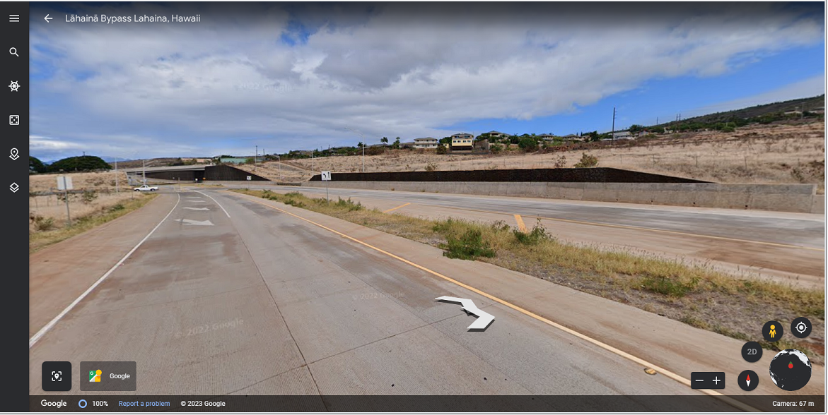
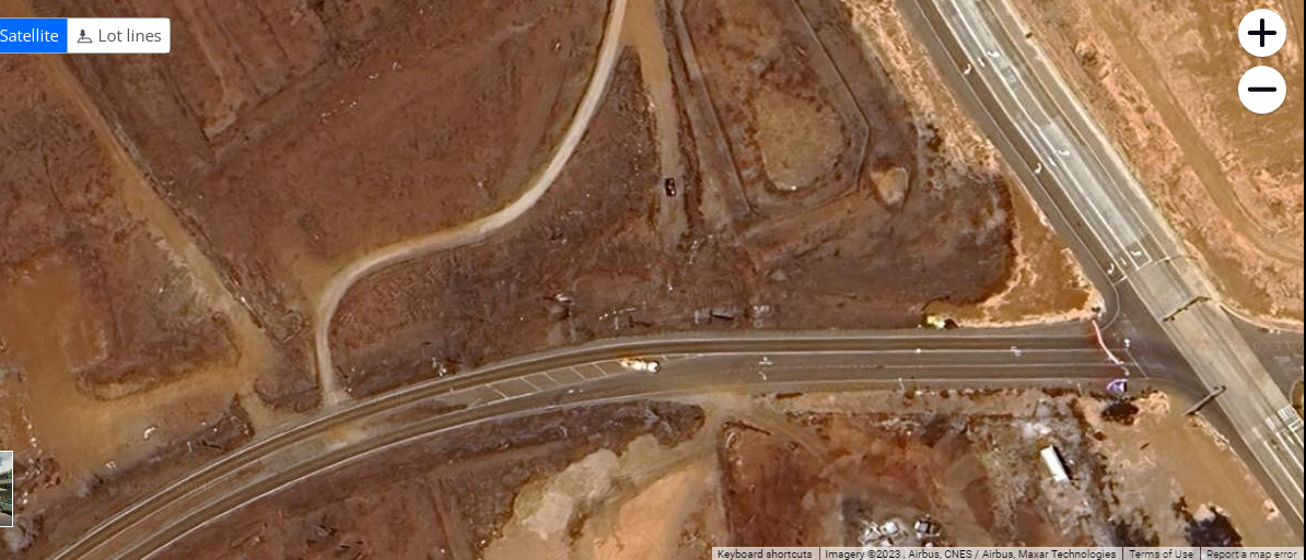
In the meantime, there was all kinds of activity up on the Bypass, including local people who drove up to get a view. Here’s a street walk from Google Earth after the fire, the first day I was able to access it (Aug25) The overpass is Lahainaluna Road. The two big homes on the right, centered above the wall, are set around the cul-de-sac with the pair of toasted cars. There are four lanes worth of pavement and a wide gravel shoulder the length of this miles-long road, enough room for the whole town to park and leave a double-lane space for responders.
Warner went up the Bypass around 5pm it seems, after waking his cousin at the Kupuohi apartments who day-slept so he could work nights. Warner told him to pack-up quickly saying he would be back –for the moment, Warner was going mauka. On his way, in an effort to help a woman crying by the road gather up her family, he traversed the high ground across to Lahainaluna Road and back again. He found the grandmother once more, reunited with her family and a van, and then he went back for his cousin. “Where do we go?” was the question. Warner told him, “Right now I know the only safe place is on top of the Bypass because you’ll be above the fire”…[minute11] https://brighteon.com/af86367c-c72d-4e3a-b1f6-f69a03ea239e
_____________________________________________________________
Getting back on the bus with Jonathan, up past the Keawe Street transition to the Bypass and around the dog-leg turn to the south, we see the wide open shoulder and unburned grass… In the center picture is the edge of the Kahoma Creek culvert as the bus rolls onto the bridge. The first picture in this threesome is the south side of Lahaina town. Another mile or so going south is the Toasted wagon (below) alone on the shoulder (photo by Eric &co). These are the natural colors of Maui’s volcanic soil.
So far, the burnt grass near this toaster is the only fire damage on the Bypass. The grass burned itself out, as grass often does. The foreground burn-spot is very curious. I found the lone wagon by satellite south of Hokiokio Place but on the night of August 8th from the NASA fire-bird image taken at 10:30pm, nothing south of Hokiokio was burning.
The red ‘x’ on the left and yellow arrow on the right position this Bypass Burner across from the south end of old Lahaina town. Was this car placed there to start a burn at the very tip of town? Does the car have anything to do with the burnt grass? The guys found a strangely flattened almost paper-like cell phone, still recognizable, on the ground right next to one of its wheels. A burner phone?
A closer look at the intersection of the Bypass with Hokiokio –in search of the brightly burning objects seen at night– seems to turn up more toasted cars.
*
Update September 14– Ann told her story of escaping the fire to the Maui Council: “If I was in my car listening to all the policemen that were out there, I would have been dead… [On foot, I] ran down… to Lahainaluna Road, got down to the light…[and] found my daughter in her truck, so I did get into a vehicle at that point. We’re being blocked right there… by a police officer[and] couldn’t go anywhere…But we just disobeyed the cops. I had my family there including the two-year-old. There was no way I was going to sit there and listen to this cop telling us to stay put…
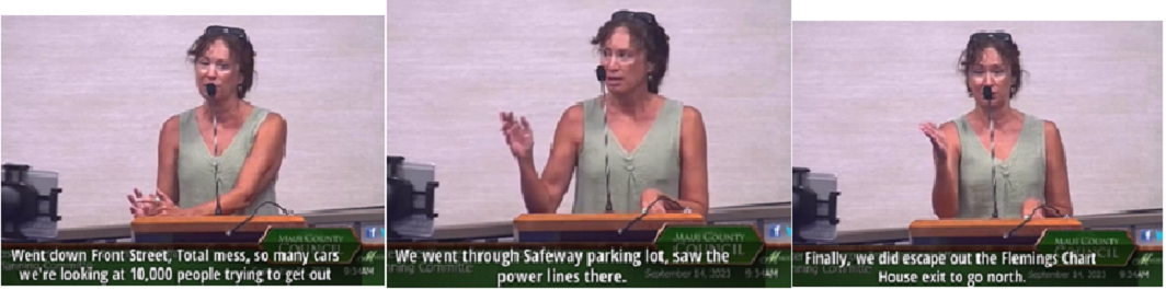
…”We went through Safeway parking lot, saw the power lines there… Everybody could have gotten out…It was free sailing going north… But the police officer there, quote unquote from other residents who talked to him [and they] were walking…all the way up to the front [of the blockade] said to the policeman there, ‘The fire is coming! You gotta let these people go.’ He [said] ‘I’ve got orders.’ We need to investigate that— who is giving these cops orders… There’s somebody above him that did this… It’s obvious we were intentionally trapped.” https://rumble.com/v3i9234-intentionally-trapped-family-blocked-by-police-narrowly-escapes-death-trap-.html
The Safeway parking lot, even though it is unburned along with everything behind it along Front Street, is hidden behind the black screen.
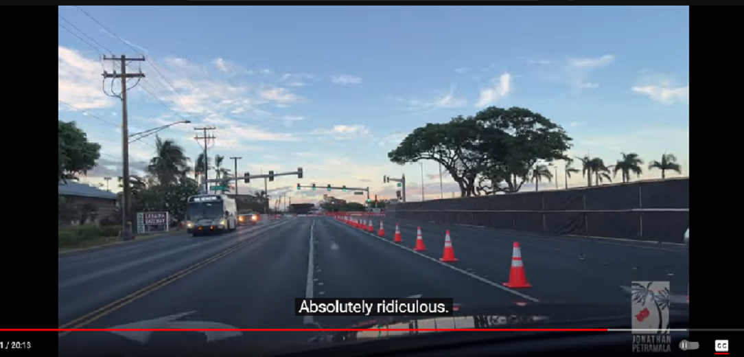
image source https://www.youtube.com/watch?v=-j-kkMk4tlk ; pictures around town Sep8.
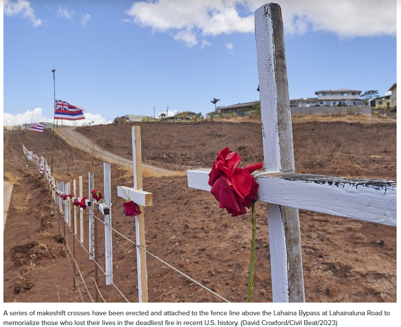
…for the record… I may not be finished yet but before you go, I’ll show you the end. This is the “makeshift” memorial that showed up on the Bypass, the safe way out: a line-up of uncountable anonymous Rosie Crosses under the Jack.
“The existence of the Rosicrucian Fraternity was first announced in what are known as the Rosicrucian manifestos of the early 17th century. This is generally considered to have occurred in 1614 when an anonymous manifesto was published in Kassel, the capital of HesseKassel (a state in present-day Germany), titled Fama Fraternitatis, des löblichen Ordens des Rosenkreuzes (‘The Proclamation of the Fraternity, of the laudable Order of the Rosie Cross’). This proclamation was placed as an appendix to Allgemeine und General Reformation der gantzen weiten Welt (‘Universal and General Reformation of the Whole Wide World’)—a German translation of the 77th Advertisement of Trajano Bocallini’s Satira Ragguagli di Parnasso (‘Advertisements from Parnassus’)—and is clearly meant to be read together with the Fama, with the two working together in partnership and thus operating the Gemini principle. The Fama Fraternitatis—which is concerned with setting in motion a universal and general reformation of the whole wide world by means of partly renewing and reducing all arts to perfection…” https://www.fbrt.org.uk/wp-content/uploads/2020/06/Secrets_of_the_Rosy_Cross.p
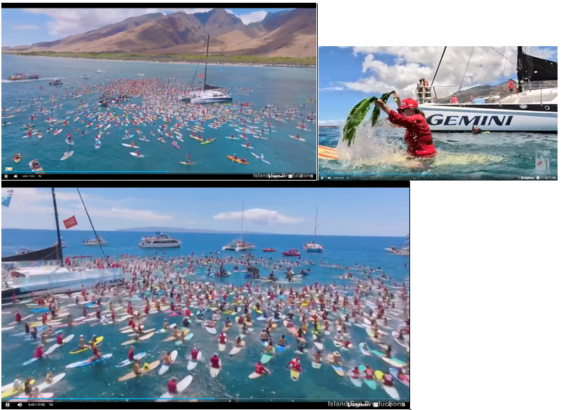
The Paddle Out and the Bypass crosses are both the public memorials shown in this video https://www.brighteon.com/08c4d139-d154-4ad1-b58e-0908265dbe43; brought to you by Island Eye Productions.
Knight of the Rose Croix is the mandatory 18th degree of Scottish Rite Freemasonry. “The Scottish Rite was established in the Hawaiian Islands by John Owen Dominis and King Kalakaua in 1874.” www.honoluluscottishritebodies.org
Prince Consort Dominis and “His marriage to Liliʻuokalani and his friendship with King Kamehameha V brought him many honors… From 1878 to 1886 he served as Royal Governor of Maui. In 1886, he was appointed Lieutenant General and Commander in Chief. According to his wife’s testimony, Governor Dominis was a very dedicated freemason and held the 33rd degree.” https://www.wikiwand.com/en/John_Owen_Dominis
The Jewel of the 18th degree:
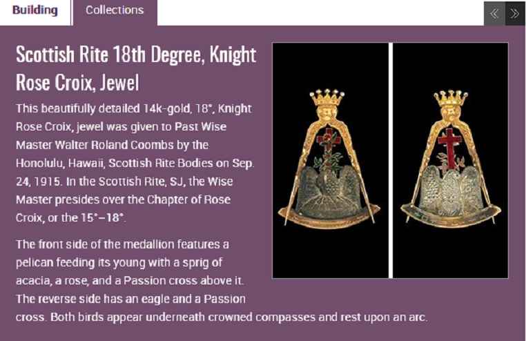
Scottish Rite 18th Degree, Knight Rose Croix, Jewel
The ceremonial Reception of the 18th degree [published 1884]: “…The stars have disappeared, the light of the sun and moon is obscured, and darkness has fallen upon the face of the earth… Our symbols and ceremonies envelop the great primitive truths, known to the first men that lived…We are about to conduct you through certain forms and ceremonies, to display to you certain symbols and emblems; we do not give you in advance their interpretation…we place the thread in your hands that will guide you through the labyrinth…” https://phoenixmasonry.org/AARS_1884_/18th_degree_knight_of_the_rose_croix.htm
Masonry’s Satanic Doctrine from Their Own Books: see the second hour for rites of conjuring (1:24:oo) where “we find detailed instructions on how to conjure Lucifer [showing the invocation text] ‘I offer Thee this incense…vouchsafe to receive it as an acceptable holocaust. Incline to me in Thy power…” and proceed to Rosicrucian “ceremonial magic” where the magician negotiates contractual terms with conjured demons “until at last a pact is agreed upon. It may read as follows: ‘I hereby promise the Great Spirit Lucifuge, Prince of Demons, that each year I will bring unto him a human soul to do with as it may please him, and in return Lucifuge promises to bestow upon me the treasures of the earth’…” https://www.brighteon.com/db7f396a-72e1-4e23-89ab-bc476e257267 ; more on Rose Crosses, the Egyptian god of the Dead and the first End Timers in America, read “Crow Notes: Places” https://jenniferlake.wordpress.com/2023/02/13/crow-notes-places/
***************************************************
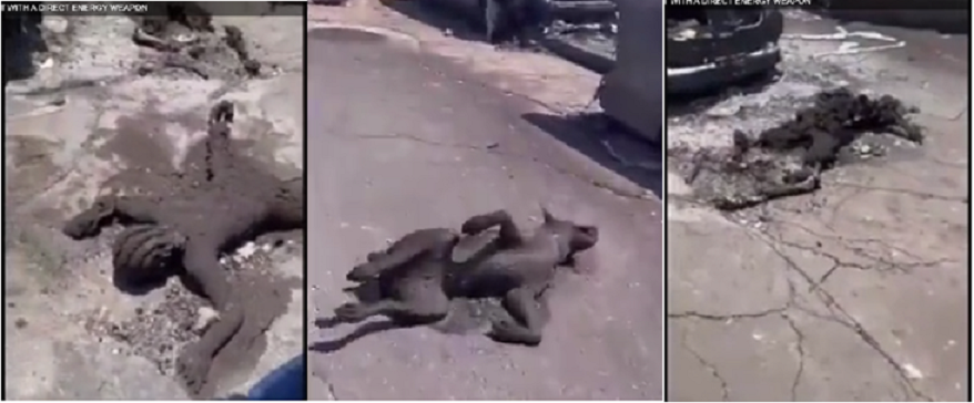
Aug10, ride with paramedics: “..so many things that don’t make sense. I have a video that I can’t show here. It’s of a cat and it’s in a walking position on all fours but it’s dead. It’s basically a statue—hairs are still on there but it basically just died instantly and stayed in that position and it’s really weird that it wouldn’t fall down. It doesn’t make sense in a regular fire, does it? I also have another video that I wish I could show you, but I can’t and I won’t and, God, I don’t even think I can talk about it… Isn’t it so bad that we can’t talk honestly and openly about things—that we might face repercussions in the future. Folks, the truth is out there, the evidence is there and you guys gotta go out and look at it and make a decision…” https://www.youtube.com/watch?v=2cp-osLVsbQ
______________________________________________________________
____________________________________
… grounding threads in the labyrinth…
Governor Josh Green signed an emergency housing proclamation on July 17, 2023. Twenty-two days later, counting from the 18th, Lahaina burned to the ground. August 8th is the 220th day of the year. The night before, shown in this screen image, is numerically 8+7+2+2+3= 22.
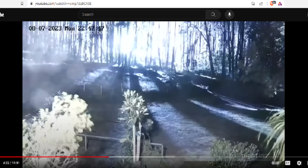
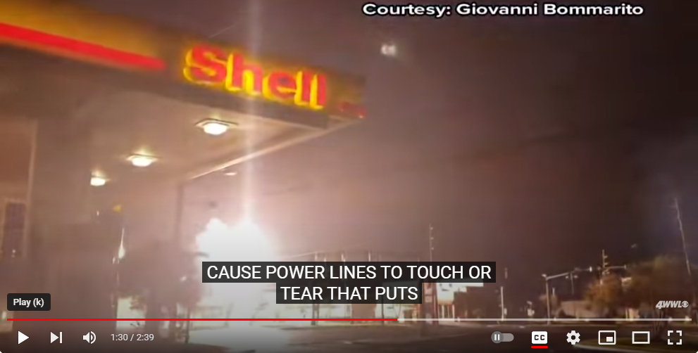
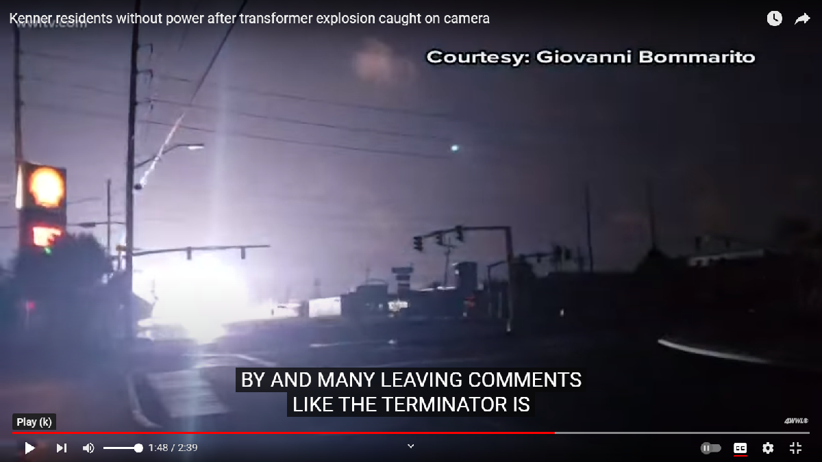
ABC Nightline news crafts the Starter story of an Upcountry (Olinda) transformer ‘flash ’the night before; the clock capture reads 8-7-2023 (8+7+2+2+3= 22) at 22:47:47
The numerology ‘thread’ of time is 22/ 22:11:11. Look back at Corona the Crow Part II for Time numerology in the decode of the movie Back To The Future.
In the next instant of this report, the clock jumps to 22:52:22, skipping almost 5 minutes. It is now 7 minutes and 38 seconds (7+3+8=18) before 11 pm and it looks like a blaze underway. The storyline suggests it “could have been a deadly trigger for these fires.” In Gematria the first given of ‘47:47’ of bright light has a meaning in reverse as ‘Jesus’ (=74) and ‘Lucifer’ (=74) being equal, balanced, reversible and interchangeable. Not what you learned in Sunday School?—me neither. ‘Reducing’ 47/47 to 11/11 symbolically contains Jesus/Lucifer in the number 22. The Upcountry news at this point had reported 19 homes burned, and that number is Time itself, or “out of time.” Gematria for TIME is 47 using a straightforward A=1, B=2, C=3 method. Masonic math, as taught, is based on the 47th Proposition of Euclid https://www.youtube.com/watch?v=aUSWQ_ytlF8
(Update) Lahaina residents were held off their burned properties until Sept. 25, 47 days after 8-8.
https://www.youtube.com/watch?v=empA8zBCX3E
ABC Nightline takes a ride aboard the Trilogy IV catamaran for this Lahaina fire special. Another day and another post, I’ll share more details about this ‘flip side’ to the tragedy– as I see it, an 18th degree Initiation.
*
*
*